No - not that Shire. We are far from Hobbitton up in New Hampshire. I drove up to Salem, NH for a short business trip - visiting the team and a bit of knowledge transfer. Since I was driving, I figured there was plenty of space in the rental car for a bike!
I loaded up my 2007 Jamis for me and my 1990 Trek Antelope for my wife. The mrs and I have been on a number of day rides over the years. I figured we would do a ride post the office on one of the 3 days I was there and she could explore the area while I was working.
So how did I find some where to ride?
I get this question all the time since I always manage to get a ride in where ever I go. Do I just have a 6th bicycle sense where I can close my eyes and feel the vibrations of bike tires over single-track? Not at all - I check out so many free online utilities such as strava that show where previous cyclists have ridden, or where there are bicycle trails like plotaroute.com or komoot.com or I will just peruse google maps. I will write up an in-depth article about this and stick it on the knowledge page as I have discovered a lot of "gotchas" as I have been routing myself over the years, however I will cover one easy one below.
--- EXHIBIT A ---
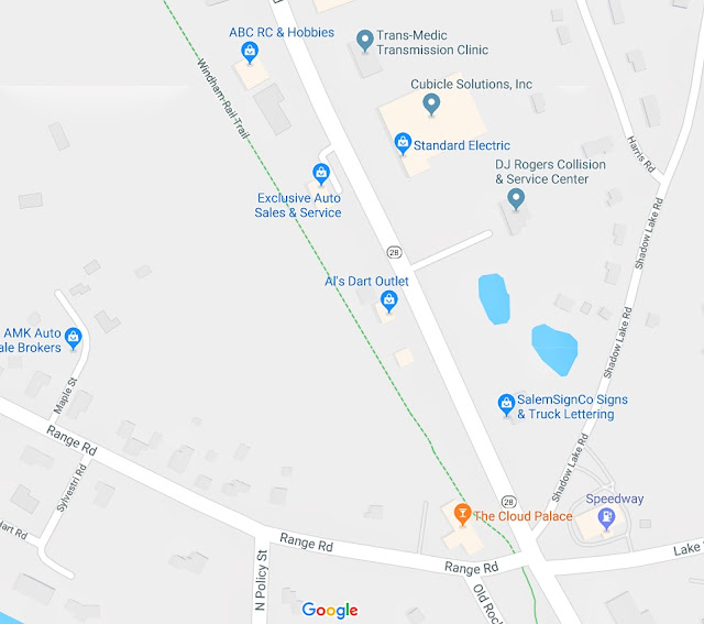
Here is a google map of the area. The grey marker in the middle of the image is where we started from and moved northwest, BUT we didnt take Range Rd ... so where you ask did we go? Into the grey areas? Excellent question - see Exhibit B below for the answer
--- EXHIBIT B ---
This image is a close up of the same area focused on the same start point from up above. You can see Range Rd as well as a dashed green line. That dashed green line represents a trail. Now I have to admit, I didn't just zoom in everywhere on the area and look for dashed green lines, I did some research prior on the area and looked for bicycle paths or walking paths. I found that in New Hampshire they had a number of Rails to Trails which is where train trails or feeder trails for the tracks are converted to recreational trails. My overall point is that a common pitfall is only using ONE method of investigation or planning. If I only used google maps, I never would have found the trail - however doing some research to know what to look for coupled with google maps made for an effective and simple one day planning combination.
A few pix and then a wrap up at the bottom.
 |
| where that rainbow flare came from I have no idea - but I will take full credit for capturing it on my phone :) |
 |
| There were a few lakes and ponds bordering the trails. |
 |
| strava route - little squiggle at the top where we stopped for drinks and got a little lost :) |
 |
| pretty flat going |

We ended up close to 19miles in total, and as you can see from the strava map above we were pretty much a straight shot on the trail with a few cut through street crossings or a few bridges where we passed over roadways.
Strava link here: https://www.strava.com/activities/2399756642
And there is no better way to close out a ride in New England than with a bowl of chowdahhh.
So what did I take away from the ride in the 'Shire
- The trails are secluded, shaded, paved and relatively flat. A few minor ups and downs on a few crossings. So no real elevations, but it would be nice to have some basic gears.
- Not too many people on the trail and for some stretches we didnt see anyone at all
- The trail goes parallel to main roads and has a number of cross streets which allows for easy access if you would like to stop and get a drink.
If I go back I would definitely take a full day, ride the trails again and try to see if I can string a few of them together prior to going and creating a route on strava I can follow.
Thank you New Hampshire!
 |
| One of the old time train cars and a section of track. This was off to the side of one of the trails |


